JH
ME-205
Featured
The Wabanaki Confederacy — Penobscot, Passamaquoddy, Maliseet, Mi’kmaq, and Abenaki peoples — held Maine for eleven thousand years before English ships came for fish and timber. Maine entered the Union in 1820 as part of the Missouri Compromise — a free state admitted to balance Missouri’s slave state admission. The first sunrise on American soil touches Cadillac Mountain. White pine made the masts that built the Royal Navy and the merchant fleet that broke from it. Lobster boats still work the granite harbors at dawn.
Maine’s 16 counties sweep from the York County beaches in the south to Aroostook County’s potato fields on the Canadian border, with a coastline so jagged its actual length is ten times its straight-line distance.
Begin with the territory that calls to you — your homeland, a frontier you love, or simply somewhere your story belongs.
Each hex is a sovereign coordinate. Pick a coastline, a valley, a city block — anywhere on the grid that resonates with your roots or your dream.
A photograph, a paragraph, a name. Your hex becomes a permanent thread in the larger national tapestry — the 250-year-old story of America, continued.
Your inscription becomes a permanent thread in the American story — and a keepsake you can print, frame, and hold.
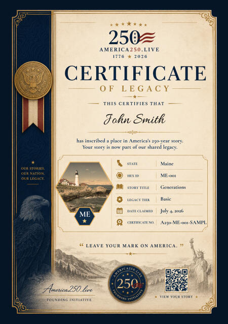
Your Commemorative Certificate
Print it. Frame it. Pass it down.
High-resolution digital certificate, custom to your state, delivered the moment your inscription is complete.
Digital Hex
Living Legacy
Your Inscription
$99 one-time · yours forever
Founder price, held through July 11. $199 afterward — and it stays there.
Maine was inhabited for at least 11,000 years before Europeans arrived. The Wabanaki Confederacy — Penobscot, Passamaquoddy, Maliseet, Mi’kmaq, and Abenaki peoples — lived along its rivers and coast in a culture finely tuned to the rhythms of cold water, dense forest, and short summers. European contact brought catastrophic disease. By the time English settlement took hold in the early 1600s, native populations had been reduced by as much as 90 percent.
The English came for fish and timber. Maine’s white pine forests were the finest mast timber in the world, and the coastal waters from Casco Bay to Grand Manan teemed with cod, herring, and mackerel. The fishing stations at Pemaquid and Saco predated the Mayflower. Maine was part of Massachusetts for two centuries, a distant province that felt Massachusetts’s governance as a burden and its neglect as an insult. The War of 1812 crystallized the grievance when Massachusetts refused to defend its northern district.
Maine became its own state in 1820 as part of the Missouri Compromise — a free state admitted to balance Missouri’s slave state admission. It arrived with a character already fully formed: independent, laconic, practical, and deeply suspicious of anything that sounded like a fancy idea from away. The word “from away” — meaning anyone not born in Maine — entered the local lexicon early and has never left.
The 19th century built an economy on ice, granite, lime, fish, and lumber. Rockland shipped lime across the eastern seaboard. The Penobscot River drove log drives that are still part of the state’s mythology. Eastport packed sardines for the world. Bath built wooden ships of such quality that Maine-built vessels were sailing every ocean. The granite from Vinalhaven and Hurricane Island paved the streets of New York City and Washington, D.C.
Today Maine navigates its identity between the tourists who come for lobster and fall foliage and the people who live here year-round through winter darkness and economic uncertainty. Acadia National Park draws three million visitors a year to Mount Desert Island. Portland’s restaurant scene has become nationally celebrated. But three-quarters of the state is unorganized territory — no town, no services, just forest, bog, and the kind of solitude that is genuinely hard to find anymore. Maine holds both realities without apology.
Samuel de Champlain charts Maine’s intricate coastline, producing the first detailed maps of the region for European navigation.
Monhegan Island operates as one of the earliest continuous fishing stations in North America, predating Plymouth Colony.
War devastates Maine’s English settlements; most colonial towns are abandoned as Wabanaki forces reclaim the territory.
The British Royal Navy bombards and burns Falmouth (present-day Portland) in October, one of the first acts of war against New England civilians.
Maine becomes the 23rd state as part of the Missouri Compromise, separating from Massachusetts after two centuries as its northern district.
Maine passes the first statewide prohibition law in the U.S., triggering a temperance movement that spreads across the country.
James G. Blaine of Augusta wins the Republican nomination for president, losing narrowly to Grover Cleveland in a famously dirty campaign.
Acadia National Park is established on Mount Desert Island as the first national park east of the Mississippi.
Margaret Chase Smith of Skowhegan, the first woman elected to both houses of Congress, seeks the Republican presidential nomination.
The Penobscot and Passamaquoddy nations settle their federal land claim for $81.5 million, the largest Native American settlement in U.S. history at the time.
Real Maine people who have placed their names — and their stories — into the hex grid. Each square mile, a chapter.
My grandfather Eladio crossed the border at El Paso in 1944, on a temporary work visa under the Bracero Program. He was twenty-three years o...
View StoryMy family has called Maine home for five generations. My great-great-grandfather Anders arrived from Sweden in 1887 with seventeen dollars a...
View StoryMy grandfather John was arrested in 1962 in Birmingham, Alabama, for refusing to leave a lunch counter. He was eighteen years old. He spent....
View StoryFor my daughter, born July 4th, 2018, at Portland Memorial Hospital. She is our American story. May the next 250 years be hers to write.
View StoryMy father served in Vietnam from 1968 to 1970. He never talked about it, not once, not even when I asked directly. He came home, married my....
View Story
Sixteen counties from Kittery to Eastport, where America’s day begins. The Wabanaki homeland, the masts of the colonial fleet, the first national park east of the Mississippi at Acadia, and lobster boats in the granite harbors. Inscribe your coast on the Pine Tree State map.
Reserve your place on the Maine map and receive your personalized Certificate of Legacy — your name, your place, preserved for the next 250 years.
We'll save your progress. We won't share your email.
Appears on the map and on your Certificate of Legacy.
We'll email you a private link to add your story and photo anytime after payment. Add your subtitle, story, and photo below before payment.
Ready · 1024 × 1024
Pick the square that lives on the map
Founder price through July 11. It becomes $199 after — and stays there.
Please accept the terms to proceed with payment.
No account needed — we'll email a secure link after payment.
Your hex is reserved immediately.
★ Limited availability per state ★
Processing
Securing your place on the map…
Check your email to complete your story and finalize your place on the map.
Can't find it? Check your spam or junk folder — and add [email protected] to your contacts so future messages reach your inbox.
Limited availability per state